The Caribbean Sea: general information
The Caribbean Sea is part of the Atlantic Ocean located in the tropics of the Wester hemisphere. The Caribbean Sea is one of the largest seas. The Caribbean coastline has many gulfs and bays.
The name "Caribbean" is derived from the Caribs, one of the dominant Native American groups in the region at the time of European contact during the late 15th century.
The Caribbean Sea was unknown to the populations of Eurasia until 1492. At that time the Western Hemisphere in general was unknown to Europeans. After being discovered, it was colonised. Following the colonisation of the Caribbean islands, the Caribbean Sea became a busy area for trading and transport, and this commerce eventually attracted piracy.
Today the area is home to 22 island territories and borders 12 continental countries. Due to the abundance of sunshine, year-round tropical temperatures moderated by the almost constant trade winds, and the great variety of scenic destinations to visit, during the second half of the 20th century on into the 21st, the Caribbean Sea became a popular place for tourism.

The Caribbean Sea is largely situated on the Caribbean Plate. The Caribbean Sea is separated from the ocean by several island arcs. This arc was formed by the collision of the South American Plate with the Caribbean Plate.
The Caribbean is home to about 9% of the world's coral reefs covering about 20,000 square miles (52,000 km2), most of which are located off the Caribbean Islands and the Central American coast.
Great Mayan Reef also known as the MBRS and being over a thousand km in length is the world's second longest. It runs along the Caribbean coasts of Mexico, Belize, Guatemala and Honduras.
The region has a high level of biodiversity and many species are endemic to the Caribbean.
Honduras's Caribbean beaches and sea

The northern coast of Honduras is a world away from the country's interior. Chaotic urban grids give way to mellow coastal towns. Steep green mountains slope sharply into verdant jungle canopies and salty turquoise waters. National parks and reserves ring vibrant beachfront promenades and port cities with sandy streets and brightly painted buildings. The residents are just as diverse, with cultures and languages. This area of river valleys and coastal plains, which most Honduras call "the north coast," or simply "the coast," has traditionally been Honduras's most exploited region.
This caribbean zone has a lot of contrast, including the most developed area of the country (Puerto Cortes and San Pedro Sula cities) and the least developed area (La Mosquitia region) with different languages (Garifuna, Misquito, Spanish) and the unique complete bilingual zone of the country (Bay Islands).

When we are talking about beautiful beaches, we cannot argue with the Bay Islands. The Bay Islands zone is sorrounded by white sand beaches, clear and warm water. But even there, if you have to pick just one beach, it’s hard to don’t think about West Bay, Roatán. A couple of kilometers of powdery sand fronted by turquoise waters, with a coral reef just a few meters offshore, West Bay is a tropical daydream. Usually people don't want to be just seeing the sunsets and probably, if you want to live some extraordinary experiences, like diving, you may be most drawn to the equally stunning reef and quirky scuba culture of Utila. Farther afield, the smallest Bay Island, Guanaja, continues to be the least-visited but offers equally extraordinary (or perhaps even better) sea life for divers and snorkelers.

The north coast beaches, especially Tela, La Ceiba and Trujillo beaches are the most visited by the local people, the prices near the area are lower than Bay Islands prices and is an easiest place to arrive to. Probably the nicest beaches on Honduras’s north coast are around the bay of Tela. A short boat ride takes visitors to the unspoiled beaches of the national park at Punta Sal, where a powdery beach with turquoise waters is backed with tropical jungle and mangrove wetlands.
A few kilometers east, La Ceiba, is a breezy stretch of sand, a good spot to spend a day or three. A couple of hours’ drive east along the coast takes you to the sleepy town of Trujillo, on a broad bay near the edge of the Mosquitia jungle.
Honduras's Caribbean biodiversity
One of the most botanically distinct coastal ecosystems are those of the islands semideciduous forest, which is found on all of Honduras main islands (Bay Islands, Swan Islands and Cayos Cochinos). This ecosystem represents a mix of both continental and Caribbean species, while on the Swan Islands it is more of an exclusively Caribbean in nature. All these islands contain endemic species of reptiles and as well as floristic elements found nowhere else in the country. The conservation status of much of this forest remains in doubt, as they are part of Marine Reserves, which are clearly much more focused on protecting the coral habitat. During the prioritisation process these islands received more points for their unique terrestrial ecosystems than they did for their aquatic ones. Many of the biodiversity is common to all the Caribbean zone, but a few (like the Utila Spiny-tailed Iguana) are endemic.


 Copán Ruins are an archeological site of an old civilization called Maya. This ruins are in the occidental part of the Country, in the department also called Copán. The word "Copan" comes from the word nahuatl "Copantl", whose meaning is "ponton" or "bridge"; This word was registred in the 16th century. From the 5th to 9th century this city was the most important capital in the clasical period. Probably the city was called by the Mayas OWITIK.
 History
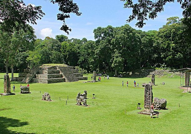 The site of Copán is composed of several architectural ensembles. The main set and the set of the cemetery are at the core of the site and are connected with the whole of the graves by a sacbe. Northeast Center of Copán had a density of 1449 structures per square kilometer. To include the area around the Center, with an area of 24.6 km², this density dropped to 143 structures/km².
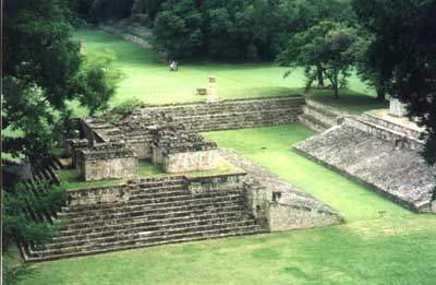 The Ball Game: considered the social Center of the city. This ball game is without a doubt the most beautiful and artistic in Mesoamerica. Singular attractions are markers, shaped head of Macaw located on the inclined walls. The last modification and construction that occurred in this set was in the days of King 18 rabbits.
 The Hieroglyphic Stairway: This great temple contains the longest text that gave us the great Maya civilization. The time was erected during the reign No. 15, known as "Smoke spiral", and it is believed is a kind of family tree of the copan dynasty, founded by Yax-Kuk-Mo. The five statues located on the steps represent five Kings before smoke jaguar. Unfortunately it has not been possible to read the glyphs, since much of the bleachers had collapsed and to rebuild the temple, they were outside their original place creating a great "glyphs soup". This temple has a tent to protect their delicate glyphs of further erosion of the environment that has already damaged large part of them.
 The Acropolis: divided in two large squareS, the East and the West. The East plaza contains the 11 Temple, built by the last King of Copán Yax-Pac, as his masterpiece. It is also in this square, the 16 Temple, with the famous altar "Q" in front of him.
 The Rosalila Temple: also known as Temple of the Sun. This temple opens a window to the past and allows us to determine how looked Copan before its fall around the year 22 of our era.


